Introducing the omlox core zone: Endless possibilities based on ultra-wideband (UWB)
Seamless location data based on UWB
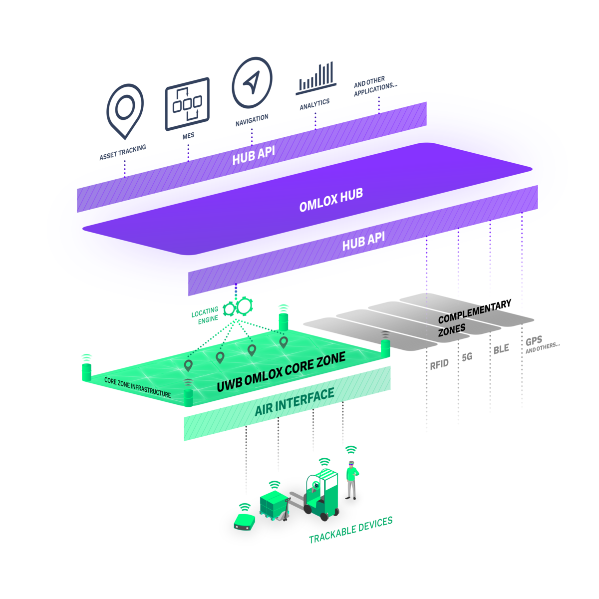
As more and more business use-cases rely on location-based data in the indoor as well as outdoor space, RTLS installations grow in size and often cover entire facilities, sites or even networks spanning various sites of different companies. Material, orders, humans, equipment or other assets of interest flexibly move within or across various sites. Still, the locating of those objects should seamlessly be enabled, regardless of the actual device manufacturer used in a specific site. The omlox architecture therefore introduces the omlox core-zone that ensures interoperability across RTLS and devices from different vendors.
What is the omlox air-interface and the omlox core zone?

Why use UWB?
The omlox core zone defines a locating zone that enables robust and precise locating of devices equipped with an ultra-wideband (UWB) radio. Therefore, an omlox core-zone spans fixed infrastructure devices (called satellites) and mobile devices (called tags) to be tracked.
- High accuracy & precision (< 10cm)
- Low sensitivity to interference
- High data transmission rates
- Low power consumption
- Guaranteed interoperability
An omlox core zone infrastructure (consisting of a locating software or engine and a network of time-synchronized satellites) communicates with tags. This enables either satellites to determine the position of tags (i.e., tracking) or enabling tags to locate themselves (i.e., self-location). The communication protocol (the omlox air-interface) between tags and satellites is defined by the omlox core zone specification. Since omlox-certified satellites as well as omlox-certified tags implement this joint air-interface, tags can easily and quickly discover the presence of an omlox core zone infrastructure and register themselves for Tracking. This plug-and-play interoperability across devices from different vendors allows flexible configurations and scalable extensions of RTLS to address numerous use-cases in industry, logistics and beyond.

The communication between an omlox core zone zone infrastructure (i.e., satellites) and mobile tags is based on a subset of the mandatory or optional physical layers described in the IEEE 802.15.4 and IEEE 802.15.4z standards. Whereas the actual ranging relies on typically regulated and therefore precious UWB signals (called In-Band signals), all other communication like device management or firmware-updates is offloaded to a separate narrow-band Out-of-Band (OoB) radio.
The second version of the omlox Core Zone Specification (omlox V2) introduces two common PHY configurations for the UWB radio:
- World-Wide configuration which satisfies global regulation: UWB channel 9 ("8 GHz" high-band operation with its center frequency at 7987.2 MHz) in base pulse repetition frequency (BPRF) mode. omlox-certified devices that feature an 8 GHz radio show an omlox air 8 logo.
- Long-Range configuration which is optimized for performance and range: UWB channel 3 ("4 GHz" low-band operation with its center frequency at 4492.8 MHz) in higher pulse repetition frequency (HPRF) mode. omlox-certified devices that feature a 4 GHz radio show an omlox air 4 logo.
Depending on the regulatory restrictions in the respective country and technological capabilities of the devices, the distance between fixed Satellites and mobile Tags in an omlox Core-Zone is calculated on one or both channels (in this case showing an omlox air 4&8 certificate) by a locating engine.
The OoB-radio is based on an IEEE 802.15.4-2020 radio (O-QPSK, §12) using the ISM band on 2.45 GHz. However, in environments where 2.45 GHz operation might be unwanted or prohibited scenarios, an omlox core zone can be configured for IB-only Mode where all OoB communication is shifted to the UWB-radio.

The Locating Engine is an integral part of an omlox core zone Infrastructure that calculates the position of tracked Tags derived from UWB-based measurements between Satellites and Tags.
Ranging and Positioning
Localisation involves two steps: During Ranging the distance between nodes (tags and satellites) is measured. This measurement is based on two principles Time of Flight (ToF) or Time Difference of Arrival (TDoA). Both principles measure the direct distance between tags and satellites (see graph). Positioning means to estimate the position. This can be realised via static localization (Trilateration, Triangulation) tracking strategies.
Version 2 of the core zone Specification features four locating techniques that can be simultaneously deployed by an omlox core zone Infrastructure. For each Tag one of the following infrastructure-centric tracking modes can be chosen:
- Two Way Ranging (TWR): Subsequent handshakes between a Tag and several Satellites allow the computation of a position based on a time-of-flight principle. This mode is highly precise, but energy-hungry and has limited scalability in terms of number of simultaneously tracked Tags.
- Uplink Time Difference of Arrival (UL-TDoA): A highly energy-efficient Tag now and then sends a blink that is received by surrounding Satellites. Since Satellites are highly synchronized, they can calculate the Tag position based on the time difference of arrival.
- Reconstructed Time of Flight (RToF): This energy optimized Two Way Ranging mode is based on a single handshake between a Tag and one Satellite that is also received and processed by other surrounding Satellites. Since Satellites are synchronized, they can calculate (reconstruct) the time of flight between all Satellites.

Furthermore, an omlox core zone Infrastructure supports Tag-centric Self-Locating similar to GPS/GNSS:
Downlink Time Difference of Arrival (DL-TDoA): To support an unlimited number of mobile devices, this mode only uses downlink signals from Satellites to Tags. Based on signals and known positions of several Satellites, the Tags can calculate their position themselves.
What's new and what are the main differences and similarities?
Click here for more information
