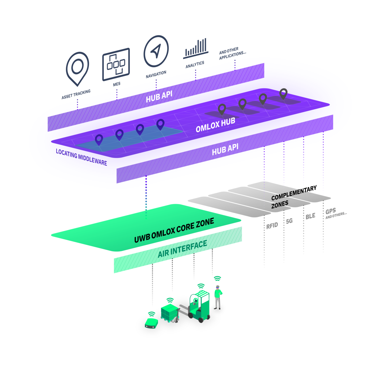
omlox provides specifications, interfaces, and defined behavior to bridge the gap between:
- Applications
- Locating Middleware
- RTLS
- Tags and “Things” (Trackables in omlox terminology)
An omlox Hub is one of the centerpieces of omlox. It is a locating middleware that enables interoperability and flexibility across different locating technologies, such as UWB, RFID, 5G, BLE, Wi-Fi, and GPS. Locating technologies can be integrated with ease, irrespective of the underlying vendor - allowing for uniform utilization of location data in a broad spectrum of applications. It is the missing glue between locating technologies and applications.
Typically, an installed locating system encompasses a physical area and refers to positions within this area using local coordinates. An omlox Hub transforms these local coordinates into standardized, global geographical coordinates. No matter which technology or vendor is in use, the global coordinates are provided in the format defined within the omlox standard.
An omlox Hub provides two connection and data transmission types – a HTTPS/REST API and a WebSocket API that define the "zone", "location provider", "trackable" and "fence" omlox entities as well as events related to the interaction of these entities, such as entering/exiting fences, collisions, and trackable motions.

The Zone API: describes the setup of a zone, including associated spatial operations like geo-coordinate transformation.
A localization zone defines an area on a floor level inside or outside a building.
A locating technology generates location data (e.g. for a tag) within a given zone.
The Zone API defines mappings between zone-local coordinates and real world (“GPS” or UTM) coordinates via ground control points.
A Zone API contains additional information about a zone (indoor floor level, address). A zone definition is required to enable locating technology and vendor independent positioning and fence events for the whole globe.
A zone definition is required to enable locating technology and vendor independent positioning and fence events for the whole globe.
Using real world coordinates allows to place fences just anywhere, separating use cases from technology and coordinate translation concerns.
The Location Provider API
Decribes the setup of a location provider and the pushing of location updates to an omlox Hub.
- A location provider in omlox terms is a positioning technology that provides location data.
- Examples: UWB Tag, Wi-Fi interface, GPS device.
- It needs to be uniquely identifiable (e.g. using its MAC address).
- A location provider delivers position data for one interface (e.g. your smartphone has GPS, Wi-Fi, iBeacon – that‘s 3 Location Providers).
The Trackable API
Is focused on handling of trackable assets within the omlox ecosystem.
- A trackable object can consist of an unlimited number of positioning devices.
- A trackable object can be localized via its positioning devices (eg. through UWB, Wi-Fi, BLE, GPS, etc.).
- This might be a mobile tag with an e-ink display, an AGV, a drone, a worker with a smartwatch, or anything else.
- While an omlox location provider refers to one positioning hardware, a trackable may be associated with many location providers.
The Fence API
Handles the creation, update, and deletion of fences.
- A fence is an area, within or across zones, where entry and exit events of trackables can be computed by an omlox Hub.
- Fences are defined in real world coordinates, allowing for the separation of locating technologies, vendors and coordinate system concerns from an application perspective.
- Convenience API exists to easily and precisely translate between coordinate systems (e.g. easily define a fence using zone-local coordinates).
Using the WebSocket API, users can easily publish or subscribe to specific events using a WebSocket connection between their application and the omlox Hub. It is possible to subscribe to location updates, fence events, collision events, and the movement of trackables.
Through this unique interoperable approach, it is now possible to streamline any location-aware application, especially when different use cases and technologies need to be combined within one infrastructure. It streamlines the integration of location-based use cases and reduces the costs associated with maintaining and expanding an infrastructure. This is even more relevant when companies aim for a truly holistic approach by connecting several sites (warehouses, production facilities, etc.). Apart from the efficiency gains, the omlox Hub allows for the creation of entirely new use cases and business models thanks to its power to utilize geofences in a technology and vendor independent manner.